




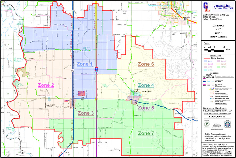
Precinct Information
Precinct #28
Central Valley Church – Halsey
Precinct #54
Shedd Fire Hall – Shedd
Precinct #73
Brownsville City Library – Brownsville
Precinct #75
Assembly of God Church – Brownsville
ZONE 1
The Northwestern portion of Central Linn. Beginning at the intersection of Highway 99 E and the northern boundary of the incorporated City of Halsey thence up the center of that highway’s right-of-way in a northerly direction to its intersection with the Fayetteville Road in the Town of Shedd, thence in a generally westerly direction up the center of the Fayetteville Road right-of-way directly to the western edge of the school district at its intersection with the Willamette River; thence northerly and then easterly along the school district boundary until that boundary intersects the Southern Pacific Railroad which leads into Brownsville; thence in a generally southerly direction down the center of the railroad’s right-of-way to a place directly east of the eastern terminus of the center of the West Linn Road right-of-way at its intersection with Seven Mile Lane; thence west to and then down the center of the West Linn Road right-of-way to the center of the Interstate 5 right-of-way; thence southerly down the center of the Interstate 5 right-of-way to its intersection with Highway 228; thence in a westerly direction down the middle of the Highway 228 right-of-way to the eastern edge of the city limits of the incorporated City of Halsey; thence northerly and then westerly along the Halsey City limits to the point of beginning.
ZONE 2
The Southwestern portion of Central Linn. Beginning at the intersection of Highway 99E and the northern boundary of the incorporated City of Halsey thence up the center of that highway’s right-of-way in a northerly direction to its intersection with the Fayetteville Road in the Town of Shedd; Thence in a generally westerly direction up the center of the Fayetteville Road right-of-way directly to the western edge of the school district at its intersection with the Willamette River; thence in a southerly and then a easterly direction along the school district boundary to its intersection with Malpass Road; thence in a northerly direction and excluding all residences having direct egress and exit to Malpass Road to the intersection with Lake Creek Drive; thence in an easterly direction and excluding all residences having direct egress and exit to Lake Creek Road to the intersection with Highway 99E; thence in a northerly direction up the center of the Highway 99E right-of -way to that road’s intersection with the southern edge of the incorporated City of Halsey; thence in a westerly direction to a point due south of 6th Street within the incorporated City of Halsey; thence in a northerly direction and including all residences having direct egress and exit to 6th Street to a point due north of the center of the right-of-way for 6th Street to its intersection with the northern boundary of the incorporated City of Halsey; thence easterly along the incorporated city limits of Halsey to the point of beginning
ZONE 3
The entire area within the incorporated City of Halsey except those areas included and identified in Zone 2.
ZONE 4
The Northern half of the incorporated City of Brownsville starting at the City limits on the east to center of Kirk Avenue, then in a westerly direction to intersection of Main Street and Kirk Avenue, then south to intersection of middle of Calapooia River and Main Street; then in westerly direction to City limits on the west.
ZONE 5
The southern half of the incorporated City of Brownsville starting at the City limits on the East to center of Kirk Avenue; then in westerly direction to intersection of Kirk Avenue and Main Street; then south of intersection of middle of Calapooia River and Main Street in a westerly direction to City limits on West.
ZONE 6
The Northeastern portion of the Central Linn School District. Beginning at the intersection of the center of the Southern Pacific line right-of-way and the northern edge of the Central Linn School District; thence in a generally easterly and then southerly direction along the edge of the school district boundary until that boundary intersects the Calapooia River; thence in a generally westerly direction down the center of that river to its intersection with the edge of the City of Brownsville; thence in a generally westerly and then northerly and then westerly and then southerly direction along the edge of the incorporated city limits to its intersection with Highway 228; thence westerly down the center of the Highway 228 right-of-way to its intersection with Interstate 5; thence northerly up the center of the Interstate 5 right-of-way to its intersection with Linn West Road; thence easterly along the center of the Linn West Road right-of -way to that road’s junction with Seven Mile Lane; thence due east to the center of the Southern Pacific Railroad right-of-way; thence in a northerly direction up the center of that right-of-way to the
point of beginning.
ZONE 7
The Southeastern portion of the Central Linn School District. Beginning at the intersection of the center of the Highway 228 right-of-way and the western edge of the Brownsville city limits, thence down the center of the Highway 228 right-of-way to its intersection with the East boundary of the incorporated City of Halsey; thence south along the east boundary of the city to the southern boundary of the incorporated City of Halsey; thence in a westerly direction along that boundary to the center of the right-of-way of Highway 99E; thence down the center of Highway 99E right-of-way in a generally southerly direction to its intersection with Lake Creek Drive; thence in a westerly direction and including all residences having direct egress and exit to Lake Creek Drive to Malpass Road; thence in a southerly direction and including all residences having egress and exit to Malpass Road to the southern boundary of the school district; thence in a generally easterly and then northerly direction along the school district boundary to its intersection with the Calapooia River; thence in a generally westerly direction down the center of that river to its intersection with the edge of the incorporated City of Brownsville; thence in a generally southerly and then westerly direction along the edge of the incorporated city limits to the point of beginning.